About
About
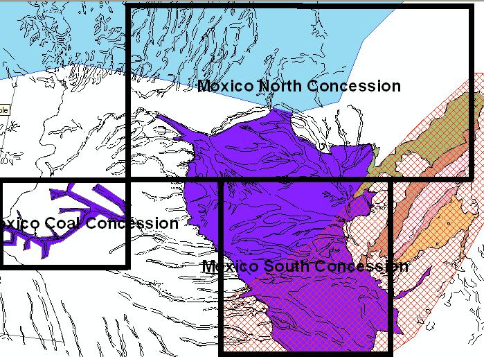
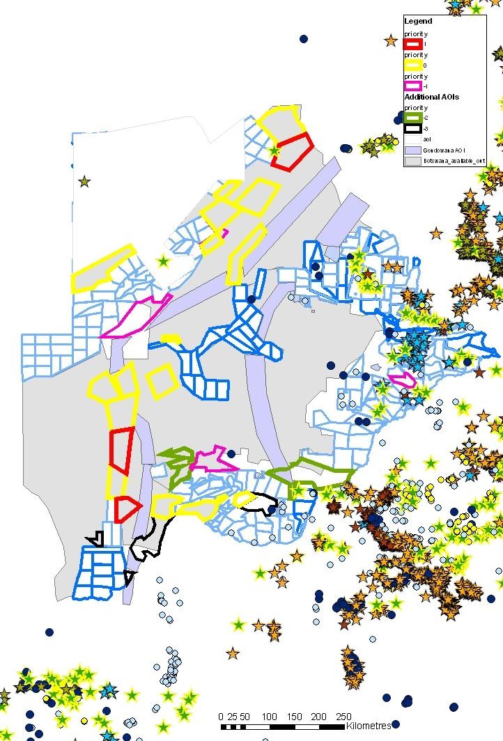
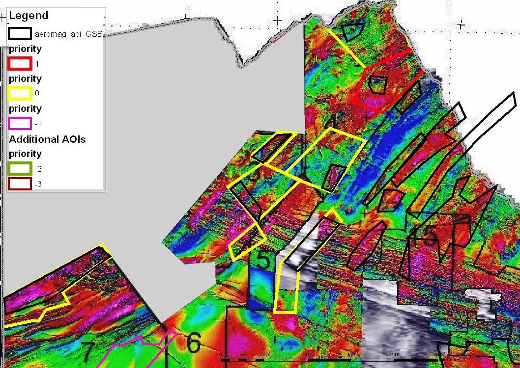
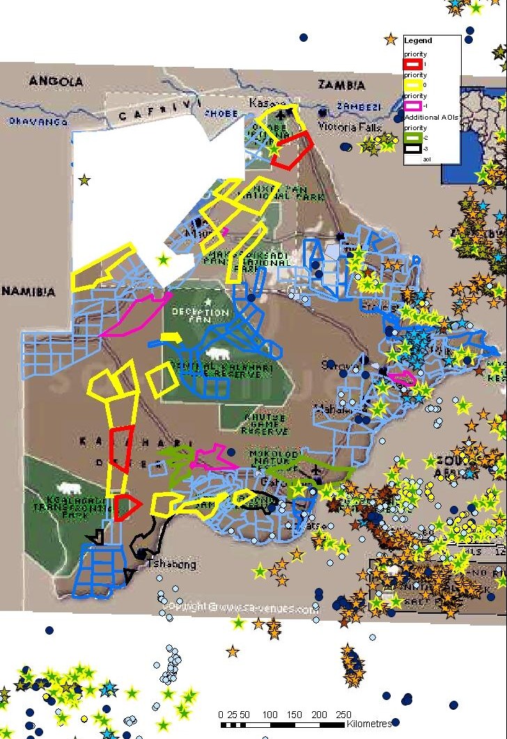
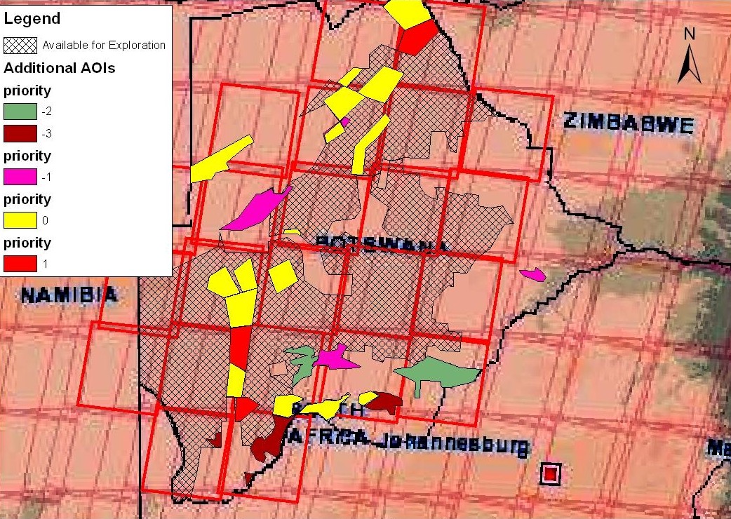
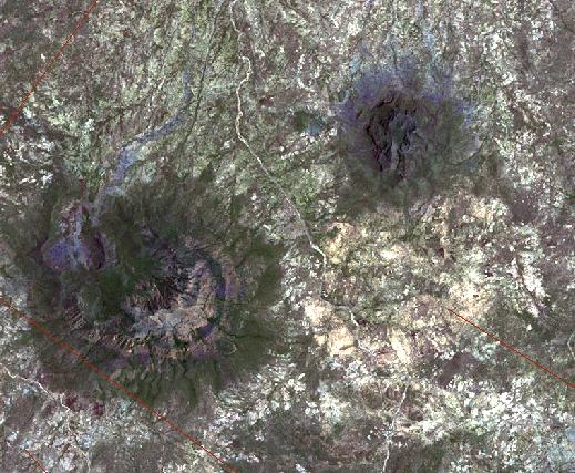
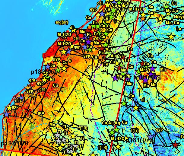
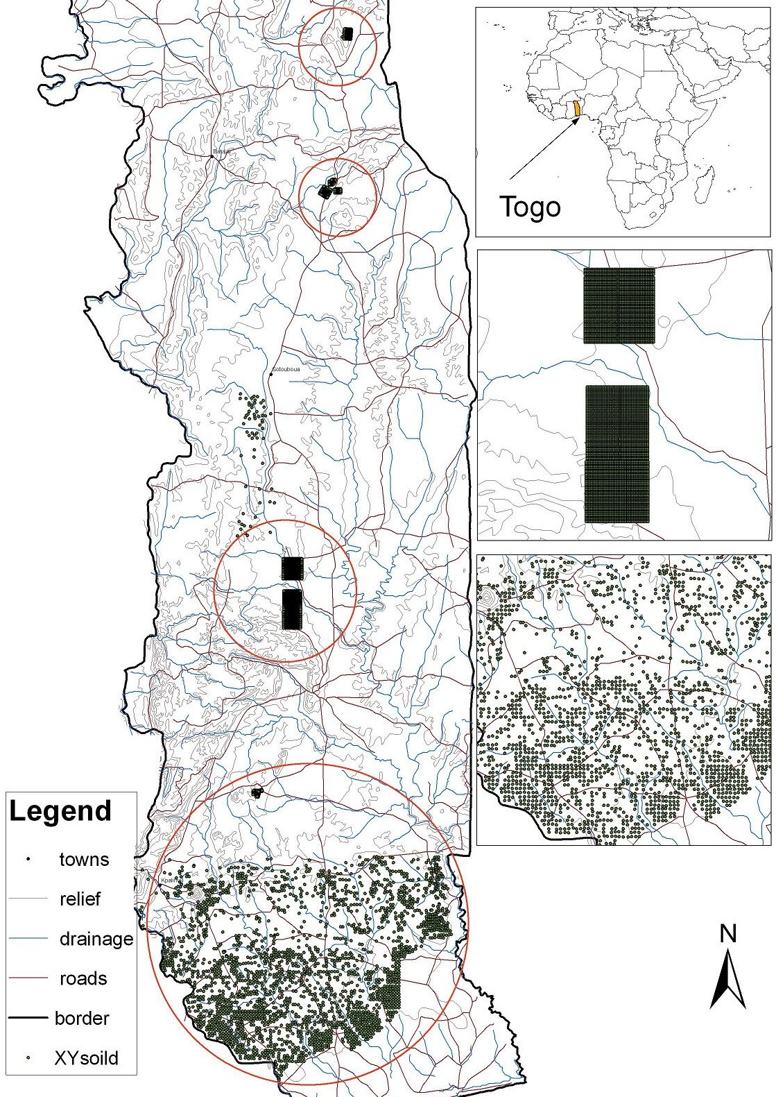
Iuma is a South African citizen and has a B.Sc. (Hons) degree in Geology, an M.Sc in Geochemistry and a PhD in Civil Engineering and GIS from the University of Cape Town. She is a professional member of the South African Council for Natural Scientific Professions which is a statutory body that monitors the ethical behaviour of its members. Membership of this body is recognized internationally for purposes of competent persons reports used in public listing documents. Iuma has worked as a GIS specialist for over 16 years in various capacities and for a wide range of applications such as: Image processing, GIS support for diamond and base metal exploration projects, regional geological analyses (Botswana/Namibia), base metal target selection etc. As an Earth Science data Spatial Analyst, Iuma has mostly been involved in diamond and base metal exploration and has consulted on projects in most of the Central and Southern African countries. She has also worked extensively in urban applications in the past and her more recent areas of interest in this field include GIS-Google Earth interfacing and 3-D models of building structures and terrain related data. Qualifications: B.Sc. (Hons) Geology, M.Sc. Geochemistry, Ph.D. Civil Engineering / Geographic Information Systems, University of Cape Town (UCT), South Africa, Pr.Sci.Nat. Languages: English, Portuguese, Afrikaans Courses: Introduction to programming ArcObjects with VBA (GIMS / ESRI, Cape Town , 29 May - 2June 2006); Landmark Forum (Landmark Education, Cape Town , February 2006) Employment History: 2008-present: Director of GIS for Tsodilo Resources Pty Limited; Director of Giscapetown (cc); Associate of VP3 Geoservices (Pty)Ltd 2001-2008: GIS Developer for: Tsodilo Resources (Pty) Ltd, VP3, CAMECO & GIS Specialist / Data processor for Fugro (FSAPL, FSBV, FSME); Liaison for AEON-Tsodilo Joint Research Projects 2007-2008: Honorary Research Associate (Department of Civil Engineering, UCT:2000); GIS Consultant for Abbot Grobicki (Pty) Ltd, Cape Town, South Africa 1996-1999: Scientific Officer and Senior Scientific Officer, Urban GIS Research Unit Civil Engineering Dept, UCT Software Experience: GIS software: ERDAS IMAGINE�, VirtualGIS�, ENVI 4.2�, ArcView� (ArcMap, ArcCatalog, ArcToolbox), Spatial Analyst�, Gemlite�, GeoMedia�, MGE MicroStation (SE/V8)�, MapInfo�; Microdem�; Accessories/Plug-ins such as: ETGeowizards�, Shape2kml�, Oasis Montaj Viewer�, Google Earth�, ERDAS Titan Viewer�, MapWindowGIS� etc..Processing software: Starfix Processing modules (Surface, Swathedit, Dtm, Contour), Triton Helix (ISIS, Delphmap) StarfixEdit; Other: Adobe Photoshop, Microsoft Office Suite, Coplot, Costat Project Experience: 2009: -Currently working on multi-surface and 3-D (planar/volume) models associated with base metal exploration in NW Ngamiland. -Developed GIS techniques for base metal exploration and kimberlite targeting in NW Ngamiland (Botswana) � A case study exhibiting the potential for 3d visualization and improved feature extraction based on Erdas, Ermapper and ArcGIS software. -Developed & Applied a proximal analysis GIS methodology for filtering magnetic anomaly targets associated with possible IOCG deposits. -Collaboration with AEON on study of Zambian copper belt-like mineralisation in Pan African Basement of northwest Botswana. -Developed a 3-Day GIS Course developed by Giscapetown: Introduction to ArcGIS (with reference to exploration geology and other industries)see: http://sudoroom.com/coursesplanned) -Developed Image filtering techniques for improved feature definition and 3-D surface modelling of aeromagnetic terrain data , NW Ngamiland. Internal Report: Tsodilo Resources (PTY) LTD, pp1-78 2008: -Proterozoic Carbonaceous Shale-Hosted Sulphide Mineral Deposit at Tsodilo Hills:The Copperbelt Ore Shale in Northwestern Botswana? Internal Report: Tsodilo Resources (PTY) LTD, pp1-21. -Botswana GIS Greenfields Exploration study covering unlicensed prospecting areas in central, southern and eastern Botswana- phase 1 for: CAMECO -Application of VTEM survey, Ternary Magnetic Anomaly and Gravity Bouger Anomaly and other data sets for base metal exploration in NW Ngamiland (internal reports for Tsodilo Resources Pty Ltd) Botswana -Contouring and plots for stream sediment survey report: Independent Technical Review of Alluvia Diamond Mining blocks Mandala River Project, Guinea, West Africa for Stellar Diamonds (P.Walker & I.Martinez) -Various GIS generated diagrams for Orapa / Jwaneng related projects (VP3) -Thematic mapping of geochemical data based on loam, rock, pit soil and other sampling surveys for Togo (VP3) -Hillshading and processing of DTM and Shuttle Radar Topography Mission (SRTM) imagery for base metal exploration in NW Ngamiland (AEON / Tsodilo Resources) -Collaboration with Impact Crater Research Group involving high resolution edge detection image processing methods for meteorite crater detection (Tsodilo Resources/ University of Witwatersrand) -Initiate GIS for Kimberlite Exploration in Tanzania (Indian Ocean Diamonds/VP3) -GIS initiated for Kimberlite Exploration in Guinea (Stellar Diamonds/VP3) 2007/2008: Joint AEON-TSODILO Resources Research Project: Research on I: the location of the Matchless Amphibolite Belt in NW Ngamiland (BOTSWANA) & II: Craton issues associated with diamondiferous kimberlite potential of NW Ngamiland (BOTSWANA) (AEON: Africa Earth Observatory Network, University of Cape Town,SA) Southern Angola LANDSAT 7 ETM+ Studies- Mineral ratio calculations and structural / geological interpretations for the Moxico Concessions (for: CAMECO / VP3) Evaluation of PCI Geomatica software for lineament extraction and edge definition based on Landsat ETM imagery -Desktop studies for base metal exploration in NW Ngamiland (Botswana) (For: Tsodilo Resources (Pty) Ltd): a)A coarse multi-variate analysis of aeromagnetics, iron-oxide Landsat image ratios, soil anomaly, lithology, tectonostratigraphic information to define potential base metal PL boundaries and target zones in NW Ngamiland(Botswana). b)Identifying broad regional relationships between the geological datasets for Botswana and Namibia, with an emphasis on the lithologies associated with base metal occurrences and a variety of other geological variables. c)A brief synopsis of some of the major characteristics of some key Cu-Ni Base metal sulphide deposits. These characteristics are then used to analyse the regional Botswana geological data with respect to the potential for similar base metal deposits in the area. d)An examination of geochemical and geophysical variations in the Kihabe area and the application of these observations to constrain areas of possible economic interest on an regional scale. Amongst the data types compared are: aeromagnetics, geology ,soil geochemistry (Pb, Zn, Cu, Ag, Ni, Cr and Mg), degree of exposure and detailed geophysics data interpretions (eg lineaments). e)A comparison of selected existing drill log descriptions and ICP data for NW Ngamiland with previous studies on the MAB Namibia. -GIS support for other diamond and base metal exploration projects based in: Guinea, SA, Tanzania, Namibia, Madagascar (for: VP3). 2005/2006: Evaluation of Hyperion, ALI, EO-1 Sat and ASTER (VNIR, SWIR and TIR) satellite data for kimberlite exploration in Botswana (current); A GIS Study of Satellite Imagery, Aeromagnetic Gradient, Fault and Lithological Boundary Proximity in the Newdico and Gcwihaba Resources Prospecting License Areas Contouring of geochemical /geophysical data (Spatial Analyst); database development; plots for PL approvals/ Quarterly Reports - Tsodilo Resources (Botswana) Profile generation and CAD support for Falcon Cable Route Project - FSME, UAE / Middle East; 2005: Multi-beam data processing support to NGT, Zeepipe, Europipe projects (Starfix: Surface, Swathedit, Dtm, contour) (FSBV); 2005: GIS database for Kimberlite pipe exploration, Tsodilo Resources Ltd.(Botswana) 2000/2004: -GIS database for West Africa - Fugro Opcos in: Holland, UK, US, SA ; Charting - Songo Songo, Tanzania ; 2003: Side Scan Imagery processing & charting - Songo Songo, Tanzania; Pilot GIS database for North Sea Dutch Sector: Gemlite evaluation; Inter-Opcos data transfer format evaluation - FSBV, Holland -StarfixEdit processing for ROV survey - Lowestoft, Scotland; Processing for SSS Survey - Mosselbay, SA; SSS image processing for Namdeb (ISIS); StarfixEdit processing & charting - Djambala, Congo; GIS Pilot database for offshore Angola - FSBV -Annual Update of Mossgas Pipeline GIS & FA Platform GIS with 2000 inspection data -Cape Metropolitan Council Catchment Management GIS project 1996-2000: -Developed GIS databases for implementation for informal settlement upgrading, Cape Town; 1996-1998: GIS for Integrated Catchment Management of the Lotus River Catchment Area; 1996: Collation, documentation and analysis of GIS-Based Visual Settlement Planning (ViSP), Belo Horizonte, Brazil -Maurice Ewing Research Vessel Cruise from Rhode Island University. Monitoring geophysical computer equipment and geochemical sampling (1994) -Stable isotope analysis of silicate minerals / gabbro ridge samples from the Okenyenya igneous complex, UCT; 1992: Electron microprobing of chromites; X-Ray Fluoresence (XRF)
|
See the following articles:
More images (2008)
More images (<2008)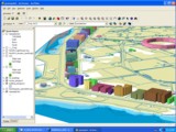 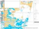 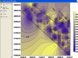 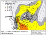 
|
|||
 IUMA MARTINEZ
 EDDIE GUILD